 Today Blanche and Lucy (along with Luey and their peoples) visited Capitol Reef National Park.
The Signature feature of Capitol Reef is the Waterpocket Fold, a 100 mile long monocline, of fold in the Earth's crust that towers as much as 2,000 ft above it's eastern base.
The park runs along the Fremont river and this is where the Fremont Indians settled and later the Mormon Pioneers called home.

As we neared the Fold the sides of the cliffs seems so imposing and loomed over us.

This Panoramic Point formation is a closer look at a part of the waterpocket fold.

The Historic Gifford Homestead, pioneer dwellings that provided a glimpse of the 19th century Utah farm life greeted us as we started our tour of the park.

A little kitchen table with flowers from their garden, eggs from their chickens greeted us as we entered the little house.

The wonderful thing about the homesteads we visited is that they still had many of the original furnishings and dishes (and in this case) wash basins that were used in that period.

And of course every little homestead had is own little Out House behind the home.

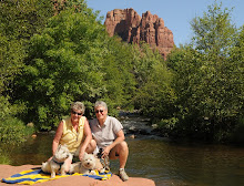
Rounding the next bend - Cathedral Rock in the distance just took our breath away.

Cathedral Rock was one of my favorites - it was so impressive and magnificent with it's jagged edges and towering sides.

As we drove through the quarter million acre park - each bend would reward us with another vista. You can see a little RV - about the size of ours just ahead of us below the rock formation - this gives you a feel for the size of these cliffs.

As we rounded the bend this was the close up of Ripple Rock that we saw- the folds and layers of sandstone are wonderfully delicate.

Through the jagged rocks we would see beautiful flowers growing..... I couldn't help but think of our friend Linda who creates the most wonderful flower photos when I shot this one.
Linda this one's for you...

The drive through Sheets Gulch was sandy and rocky and we were happy for 4 wheel drive... but we were rewarded with beautiful vista like this one in Burro Wash where the time and weather formed the sandstone into lovely ripple and folds formations.

To give you a feeling of size - Cheryl & I stood beside the rock formation in Burro Wash.

If you double click and enlarge this photo it will tell you about the Old Fruita Schoolhouse in the next photo. This schoolhouse was in operation till 1941 and closed due to a decline in enrollment.

This is the old Fruita one room Schoolhouse built in 1896 by the Mormon settlers in Fruita who donated the land and the money for the teacher's salary for the education of their children.

Look closely at the next few photos to see ancient Pictographs and Petroglyphs painted and carved into the sandstone by some of the area's early native inhabitants - the Fremont Indians. We sat and stared for a long time to find all the areas where these drawings were located along the face of the canyon walls.... they are very subtle so not immediately apparent.

There are significance to each of the drawings that tell the story of these early inhabitants. Signage in the area explain many of what they though the drawings meant.

If you find any of these Petroglyphs difficult to see just double click on the photo to enlarge and see better.
Unfortunately we humans can ruin beauty... can you see the bullet holes in the pictographs? Stupid people with guns decided this would make fun target practice. Shame on them.

No comments:
Post a Comment